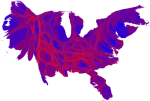
Locating Obamaland, Cotton and Presidents, and Accurately Rendering American Divides
Posted by Stephen Lewis on November 20, 2008
Further to Purple v. Pixilated below and JP Rangaswami on Reds and Blues and Purples, I point to two recent entries on the excellent weblog Strange Maps. In Where is Obamaland?, Strange Maps takes us first from the state level to the county level and then (via Mark Newman of the Physics Dept. at the Univerity of Michigan) to a series of cartograms (click here) that transcend the strictures and dogmas of traditional cartographic projections to chart the boundaries of the political fault-lines that divide the US. Newman’s cartograms hint at the importance of intentional relationships vs. strictly spatial ones in characterizing and understanding our world. Newman’s final cartogram (illustration above) provides an solid point of departure for discussing the effects of settlement patterns, historical asynchronicities, ethnic self-identification, and shifting demographics and economic differentiation on American politics and worldviews. In From Pickin’ Cotton to Pickin’ Presidents, Strange Maps illustrates how the abberations of the economies and social orders of the seemingly distant past invariably echo in the present, taking the arcane case of the correlation of pockets of deep-south support for Obama with the geographic distribution of mid-19th-century cotton culture.

Gerrymandering the Internet, Continued « Hak Pak Sak said
[…] of infrastructure. It also interprets how we interpret the significance political mandates (see this past post on the mapping of the recent US presidential election). A new form of gerrymandering, apparently, […]